 9026*08 NV CHARTS Seekarten plano Koffer Ostsee, Serie 1-4 - Bild 1
 9026*08 NV CHARTS Seekarten plano Koffer Ostsee, Serie 1-4 - Bild 2
 9026*08 NV CHARTS Seekarten plano Koffer Ostsee, Serie 1-4 - Bild 3
 9026*08 NV CHARTS Seekarten plano Koffer Ostsee, Serie 1-4 - Bild 4
 9026*08 NV CHARTS Seekarten plano Koffer Ostsee, Serie 1-4 - Bild 5
 9026*08 NV CHARTS Seekarten plano Koffer Ostsee, Serie 1-4 - Bild 6
 9026*08 NV CHARTS Seekarten plano Koffer Ostsee, Serie 1-4 - Bild 7
NV CHARTS Chart Box Baltic Sea series 1-4

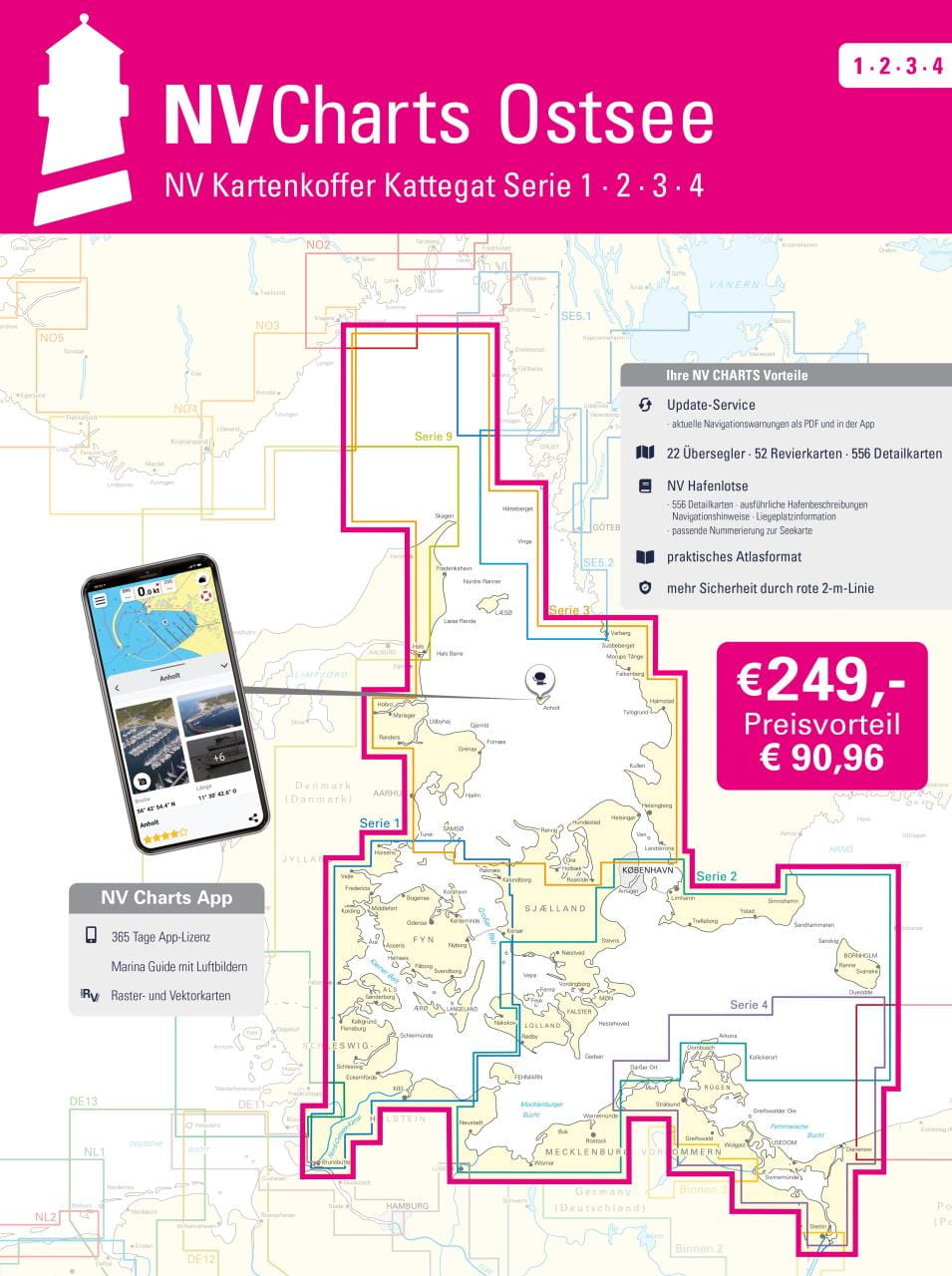
The Baltic Sea from Skagen to Bornholm: The Baltic Sea chart sets 1-4 of the sport boat chart publisher NAUTISCHE VERÖFFENTLICHUNGEN we also supply as a complete package in a practical transparent plastic case at an attractive preferential price. The proven handy charts are arranged in sets according to cruising areas. All information is specially prepared for the requirements of recreational boating.
The Baltic Sea case includes
- 20 Passage Charts
- 42 Coastal charts & detailed charts
- nv charts app and navigation software 365 days licence
- new: Vector charts download
- Harbour Pilot in paper / digital in German and English
- Navigation instructions in German
- Meets legal requirement for up-to-date paper nautical charts on board pleasure boats
All NV Verlag / NV Charts also include an access code to the digital nautical charts in the NV Charts app and can thus be easily downloaded. The charts can be used for 365 days from activation for offline navigation with the NV Charts App on iOS, Android, PC and Mac or also in the web browser.
Updated editions of the charts are published annually (usually in March). Up-to-date nautical charts are the basis of safe navigation. NV Charts offers a monthly correction service for its nautical charts from April to October.
Chart format 60 x 42 cm.
All four chart sets in transparent plastic case.
German edition.
€249.00*
€249.00*
Prices incl. VAT plus shipping costs
Description
The Baltic Sea from Skagen to Bornholm: The Baltic Sea chart sets 1-4 of the sport boat chart publisher NAUTISCHE VERÖFFENTLICHUNGEN we also supply as a complete package in a practical transparent plastic case at an attractive preferential price. The proven handy charts are arranged in sets according to cruising areas. All information is specially prepared for the requirements of recreational boating.
The Baltic Sea case includes
- 20 Passage Charts
- 42 Coastal charts & detailed charts
- nv charts app and navigation software 365 days licence
- new: Vector charts download
- Harbour Pilot in paper / digital in German and English
- Navigation instructions in German
- Meets legal requirement for up-to-date paper nautical charts on board pleasure boats
All NV Verlag / NV Charts also include an access code to the digital nautical charts in the NV Charts app and can thus be easily downloaded. The charts can be used for 365 days from activation for offline navigation with the NV Charts App on iOS, Android, PC and Mac or also in the web browser.
Updated editions of the charts are published annually (usually in March). Up-to-date nautical charts are the basis of safe navigation. NV Charts offers a monthly correction service for its nautical charts from April to October.
Chart format 60 x 42 cm.
All four chart sets in transparent plastic case.
German edition.


